
Geology of the Yucatan Peninsula
A large, flat broccoli. That was my first impression of the Yucatan Peninsula years ago when my plane began its landing at Cancun airport.
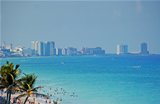
The Yucatan Peninsula is a plateau of more or less 300,000 sq.km (115,800 sq. miles). Roughly about half of this landslab is above sea-level.
"Beginnings are apt to be shadowy and so it is the beginnings of the great mother life, the sea." (Rachel Louise Carson)
Actually what is now called Yucatan is one of the youngest pieces of earth, according to geologists. From the bottom of the ocean, layers of sediment mixed with trillions of tiny skeletons from crustaceans and other small sea-creatures started to build up from as far as 200 million years back ( which is close to nothing in terms of evolution). Like an upside down Atlantis the plateau eventually rose above sea-level.
Because of the porous limestone underground the absence of surface water is remarkable. Below the surface however you'll find one of the most extended underground drainage systems in the world where cave diving has become a major attraction.
Imagine yourself a subway system. The lines are the underground freshwater currents that eventually flow into the Caribbean sea at places like Xcaret and Xel Ha. The latter means "where water mixes". What would be the "stations" of this subway system are large freshwater basins called cenotes.

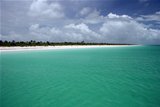
The Yucatan Straight is a narrow and shallow channel which separates the peninsula from Cuba. Here, water streaming from the Caribbean Sea is forced into the Mexican Gulf. This makes the Yucatan Current essential to the eventual forming of the Gulf Stream. Steve Gittings, NOAA Marine Researcher, compares these currents to 'liquid winds', because they take with them plant spores and animal larvae to other areas along its path, thus supplying other habitats. Imagine a giant sieve into this huge bassin which is the Mexican Gulf. Meanwhile downstream to the Yucatan Current thousands of tropical species abound on the Mesoamerican Barrier Reef System, the largest reef system on the Northern Hemisphere. Jacques Cousteau was the one who placed Cozumel back on the world map with his early underwater films. He is remembered with a submerged statue off the island coast.
A big bang

65 to 60 million years back, the odd dinosaur in the region may have looked up in amazement to a huge ball of fire in the skies. Not knowing, of course, that that ball was the prelude to the end of him and his kind (the event and its consequences are still debated).
The asteroide came down on the Northwestern edge of the Yucatan Peninsula, forming an enormous crater of 160 km (99 miles) in diameter and 40 km (25 miles) deep. Giant clouds of dust and particles went up into the earths atmosphere, preventing photosynthesis and causing the extinction of practically all life. Today, this meteor crater is known as the Chixchulub crater, named after the village in its epicenter. It is visible from outer space. On satellite photos you can see the asteroid impact was half on land, half in the ocean.
The heartland of Maya Civilization
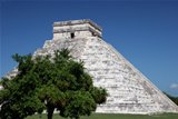
The northern half of the Yucatan Peninsula is almost entirely flat. The only "Alps" you'll find are actually the Mayan temples rising above the jungle canopy. The main temple at Cobá is known as the tallest of northeastern Yucatan, 42 metres (138 feet). You an (still) climb it. The one at Chichen Itza is (definitely?) closed to the public. Standing on top you have a spectacular view for miles around . In archaeologal terms these are the Northern lowlands.
Logically there is a counterpart called the Southern lowlands, where low hills are covered with the tropical forest of South Yucatan and Northern Guatemala. This was truly the heartland of Classic Maya civilization, where in the 6th century AD Tikal in Guatemala and Calakmul in southern Campeche dominated the Mayan World. War between these two superpowers possibly had played a major role in the Classic Maya collapse around 800 AD.
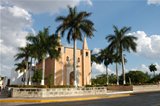
To the south of Merida there is a rim of hills called the Sierrita de Ticul or Puuc hills. Average height is only about 200 m (658 feet) above sea-level but that's enough for local pride to kick in. This area was once densely populated by the Mayan people (700 - 1000 AD) and famous for its splendid architecture and mosaic sculpture depicting the mask of the Rain God, Chaac.
Cenotes

As I mentioned before, the absence of surface water is a main trait of the Yucatan Peninsula. On your drive you won't cross any bridges that are not ment to cross the highway between Merida and Cancun. No rivers flow through the landscape, no stream or kreek to enliven your pictures.
The porous limestone and the thin layer of soil prevents rainwater from being captured at the surface where in time it could form a river. Instead, rainwater filters through until it hits the bedrock, turns acid and starts eating away the limestone. This process over time translates into the formation of arguably the most extensive underground drainage system in the world.
In recent years these underground caves and rivers of the Yucatan Peninsula have become inmensely popular for cave diving.
In some areas the water is very close to the surface or more easily accessible at places where the 'ceiling' has collapsed. An aereal view would be something like a Swiss cheese. These sinkholes are called cenotes in Spanish, a term derived from the Yucatec Maya word dzonot. There are many of them in the northern part of the Yucatan Peninsula, a report for the Yucatan state alone gives a number between 7,000 and 8,000! One of the largest is the Well of Sacrifice at Chichen Itzá ("che'en" means "mirror of water"). Many cenotes are interconnected through underground caverns and waterways, the extent of which is still largely unknown, though there have been important mapping projects.
Webcam Search
Take a peek at our beaches through one of our webcams.

Accommodation

Search for your favorite hotel, compare services, features and prices and look for special offers!

Isla Mujeres


- Peninsula
- Cancun
- Resorts
- Riviera Maya
- Clothing Optional
- Haciendas
Where to stay
- ©Beautiful Yucatan Peninsula 2008 - 2009